Monday 27 June 2016

Kilo Bravo vers Huberdeau

(text and photos by Karl Boutin; posted by Dan)

Let me tell you about two flights, two Fridays apart. Same task, same glider but two different cross-country adventures. In both cases, we were trying to organise mid-week flying operations in order to enjoy the great looking flying forecast that May or June can provide here in the North East. These few weeks of late spring are the best to plan long tasks or badge leg attempts.

Rémy and I keep in the memory of our Nano III flight recorder a few tasks ready for such days. We have different courses to match different possible weather conditions we can expect on a specific day. Before putting KB (Karl and Rémy's ASW-20 - ed.) on the grid, and once the latest 10 am Dr Jack (online meteorological site - ed.) update has been produced, we load up in the device the better task for the day. On June 3rd, Rémy chose a 300 km cat’s cradle task that would benefit from the good conditions expected north of the river. Pendleton - Cheneyville - Cornwall - Huberdeau - Pendleton makes a nice “N” course running north-south over the Ottawa river. It is the exact same task I attempted two weeks later to benefit, as he did, from the promised Cu’s that were going to pop over the northern hills.

Both Fridays were great flying days but the latter was a boomer! Cumulus did form around 14:00 over Pendleton on June 17 and cloudbase did reach into the 10000 ft MSL during that day. That may explain why I was able to get my Gold distance leg out of this flight. My partner, on the other hand, finished the afternoon of his flight on the porch of Brian & Lise’s mansion in Avoca, sipping white Chardonnay, while his partner was on his way for the retrieve!

Rémy and hosts (pretty blue sky...)
ASW-20 "KB" at sunset


 Have a look at both traces and you will be able to see the difference between those two flying days. The working band heights, the thermal strength, the wind drift and BS ratio (buoyancy to shear ratio - measure of how well thermals form and rise, or are torn apart by the wind -ed.) were all conditions that made for two very different stories.

Rémy's trace (map, altitude vs time, green is ground height)


Karl's trace


And what did we learn from this?

         “Quand tu pars pour Huberdeau avec Kilo Bravo, t’es mieux d’être haut!’”

Friday 17 June 2016

Even not so good pilots (like Martin says...just kidding) can have epic flights. This time was my turn. On June 4th, I managed to soar for 6 hrs 10 min. My lower back still hurts ;)
I should able to apply for a Silver Badge duration leg (5 hours or more). Rather than bragging about it, my intention is to share the happiness with other glider pilots and soon-to-be glider pilots. The peaceful times you experience when soaring are priceless.
Cheers
Roberto-
 
Pendleton was a very busy airport during this year's MayFly.......Many guest pilots, very colorful Spring landscape, time to rest in the shade under a glider's wing and even dust devils. It is always a memorable event organized by GGC every year. Congrats to organizers, pilots, and people that supported the event. Please see below a few pictures. You can also see more photos under:
https://goo.gl/photos/FeasKMQAsxqX1y4s8
https://goo.gl/photos/WNATTJEPE1shR51Z6
Cheers
Roberto-


Sunday 12 June 2016

Windy wavy Sunday, June 12

As I sit in Kanata, I can hear the wind. Mother Nature is unhappy...  The public forecast says it's a NW wind, 24 gusting 44 kph.  I wondered if there would be wave with that wind.  I took a look at the visible NE satellite view; yup. Wave in Ontario, NY, Vermont, New Hampshire, and also, as far south as Pennsylvania (no marker clouds in the blue, but it's probably wavy to Williamsport.

Here's the satellite shot, and the winds aloft at Plattsburg, NY (which we use as an indicator for Lake Placid wave).

On the satellite shot, you can see gaps in the clouds; these are:

"foehn gap

A break in an extensive cloud deck or cloud shield, usually a band parallel to and downwind of the mountain ridge line.

Especially visible in satellite pictures, this cloud-free zone results from the strong sinking motion on the lee side of a mountain barrier during a foehn or chinook."


Specifically, the sinking motion increases the pressure, which heats the air, which allows it to hold more moisture... Same effect that heats a pump when you inflate a bike tire.

The Terminal Airdrome Forecast for Saranac Lake (KSLK) - the closest airport with a forecast - shows:

TAF: KSLK 121126Z 1212/1312 VRB06KT P6SM OVC025 FM121300 29015G26KT P6SM BKN035 FM121700 29015G27KT 4SM -SHRA BR OVC030 FM130000 30012G21KT 4SM -SHRA BR OVC020 FM130200 30011G20KT P6SM VCSH OVC020 FM131000 30009KT P6SM OVC020

We'd probably plan runway 32 in Lake Placid, and look for the wave at Whiteface.  It will be a bouncy sorta day for sightseeing rides with Adirondack Air Services!

Even on a 'sucky' day, you can learn something!  The club plans to do a mountain soaring camp again this year, October 1-10.  

 
Wind Forecast

9:30 am visible Satellite

Lake Placid airport (photo by Dan Duclos)
 

In Foehn Gap at Lake Placid, 2014; Lake Placid in the shadow. Wave clouds...


Wednesday 8 June 2016

Early season summary of cross-country flying and a couple of ridge pictures

As June starts, a review of the season shows a reasonable start. 9 club pilots have flown 43 flights in the Canadian Online Contest ( onlinecontest.org ).  The usual goals are flying the distance across Canada (6,521 km), once around the Earth (40,075 km), and for the Soaring Association of Canada, the distance from the Earth to the Moon (384,400 km).

How are we doing?  As of 8 June, GGC pilots have claimed 6,817 km of cross-country flying (flights in Canada only, 8187 km in North America) - so we have already flown across Canada, and are on our way back! We're less than a quarter of the way around the Earth, but La Nina usually gives us a dry summer, which is great, compared to El Nino, which gives lower cloud bases and shorter distances.  SAC has flown 209,309 km cross-country so far, more than halfway to the Moon (54.5%)!

We are working on FAI badge claims for two "C" Badges (one hour after release), two "Silver Duration" flights - five hours (aka "The Big Sit"), and a number of pilots are chasing the elusive 300 km "Gold Distance" flights (closest so far made 260 km before going "Aux vaches" - 'to the cows').  There was one 750 km "Diploma" flight attempt in the US which failed due to a power interruption on the flight recorder on a turbulent day.

All of this, in aircraft without engines, all solar powered.  The club has four single seat gliders; those doing Badge attempts just show up at 0900 at the Hangar and declare a flight, and the glider is theirs for the day (a few times a season). Each is equipped with a flight recorder (TR, our L-33, needs to use a club Colibri logger, the others have PowerFLARM IGC Flight Recorders).

We know a lot of pilots are flying a lot more km than we are claiming. The OLC is a great place to store your IGC files, and it is simple to do.

Will we make it once around the Earth?  Will SAC make it to the moon?  Stay tuned...

Two photos of flying at the Ridge in Pennsylvania... one, just floating down the ridge, about 1,500' above it, with north winds giving ridge lift (about 3 knots at this speed). You can see how the thermals are concentrated by the wind along the ridge. Very convenient to find lift... if there are Cu.

Click to make larger


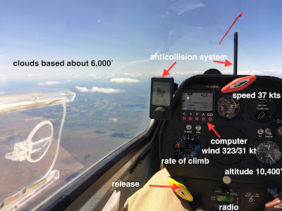
Second, on a different flight, the air was more stable, and dropped off the plateau, rebounded off the ground, and made a wave. The plateau is 2,000' above sea level, the wave went much higher than you might expect... here, I'm passing 10,400', and I made it to 11,500' eventually (limited to 18,000' in the US, unless you have a letter of agreement with Air Traffic Control, 12,500' in Eastern Canada; you are required to use oxygen in Canada above 13,000'); very gentle lift. This is the first time I've flown wave in PA; very different than Colorado or Lake Placid.  This wave was falling on the ridge, just downwind, and 'suppressing' the ridge, which caused a little consternation for those who assumed it would be 'working'... but no one landed out.  It's kind of magic, gently climbing above the clouds... For pilots, notice the attitude difference for 52 kts vs 37 kts...

Gliding/Soaring - every day is different